8 Scenic Road Trips That Showcase California’s Diverse Beauty
Since the automobile democratized travel in the early 20th century, the road trip has been a distinctly American pastime. California is uniquely suited to hitting the open road, given its natural beauty, sunny disposition, and diverse topography. We’ve rounded up eight California road trips that meander through some of the state’s most impressive landscapes, proving that sometimes the journey is as important as the destination.
Breathtakingly Rugged Coastline Along Northern Highway 1
Start: San Francisco, CA
End: Leggett, CA
Total Distance: 218 miles
Recommended time: Three to five days
While the most popular stretch of California’s legendary Highway 1 runs from Los Angeles through Big Sur to San Francisco, the route is often plagued with road closures* and traffic jams. For a far less crowded but no less breathtaking coastal road trip, travel north from San Francisco through Marin, Sonoma, and Mendocino Counties to the remote, northernmost terminus of Highway 1 in Leggett.
Leaving San Francisco, you’ll cross the iconic Golden Gate Bridge and skirt the edge of the Golden Gate National Recreation Area, Muir Woods National Monument, Mount Tamalpais, and the Point Reyes National Seashore. Roads and trails crisscrossing this stunning collection of parklands just outside the city lead visitors over headlands and through redwoods to stunning overlooks, quiet beach coves, lighthouses, elephant seal rookeries, grasslands with grazing elk, and more. Along the tranquil waters of Tomales Bay, feast on fresh oysters and stay overnight in a waterside cottage at Nick’s Cove.
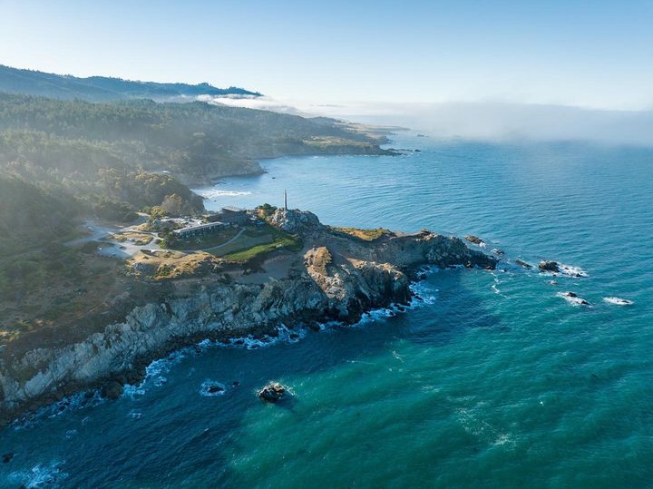
The next day, Highway 1 turns inward briefly to pass through bucolic swaths of rural Sonoma County before rejoining the sea in the charming fishing village of Bodega Bay. From here, the highway hugs the coastline for miles, providing jaw-dropping views at every turn. Visit a historic Russian fort at Fort Ross State Historic Park. Stop at Schooner Gulch State Beach at low tide to see the rounded sandstone formations resembling bowling balls. In Point Arena, climb the historic, 115-foot Point Arena Lighthouse to take in the panoramic views and look for whales passing offshore.
Grab a drink and a bite (and consider staying the night) at the iconic Timber Cove Resort. Perched on 25 acres of rugged coastline, the oceanfront resort underwent a full renovation in 2016 but retains its midcentury vibe. Other places to stay along this stretch include the bucolic coastal retreat at Mar Vista Farm + Cottages and Wildflower Boutique Motel, a former abandoned motor lodge transformed into a hip, eco-friendly motel.
From Point Arena, the highway continues along the dramatic coastline passing through charming small towns founded during the logging boom of the late 19th century. Among the most picturesque is the village of Mendocino, which is perched on a bluff overlooking the ocean. It features fine restaurants, art galleries, and several Victorian B&Bs including the Inns of Mendocino, MacCallum House, and Headlands Inn. Take a stroll along the ocean bluffs, paddle Big River in an outrigger canoe, or hike into the redwoods at Russian Gulch State Park.
Further north in Fort Bragg, enjoy the stunning blooms and ocean views at the Mendocino Coast Botanical Gardens or journey into the redwoods aboard the historic Skunk Train. Leaving town, the two-lane highway curves through remote landscapes with windswept cliffs and frothy waves crashing against the rocks.
The tiny hamlet of Westport is the last town before the highway turns inland, twisting and rising through redwood-forested mountains to terminate at US 101 near Leggett. Stay a night at the handsomely renovated Westport Hotel to enjoy the beauty and solitude of this northernmost stretch of Highway 1.
*Regarding the current Highway 1 closure in Big Sur, Caltrans estimates completion of the Rocky Creek roadway stabilization work and unrestricted reopening of the highway by May 27, 2024.
Directions
From San Francisco, follow CA-1 north to its terminus at US 101 in Leggett.
Google Maps Link
Waterfalls and Volcanic Features on the Volcanic Legacy Scenic Byway
Start: McCloud, CA
End: Lassen Volcanic National Park
Total Distance: 219 miles
Recommended time: Two to four days
This short trip showcases how volcanic activity eventually gives way to dense forests, sweeping wildflower meadows, pristine lakes, rushing rivers, and plunging waterfalls. The drive begins at the base of Mount Shasta, in the former lumber town of McCloud. A stay at McCloud Hotel is the perfect kickoff, given its location right on the Volcanic Legacy Scenic Byway and its history as a popular vacation destination since 1916.
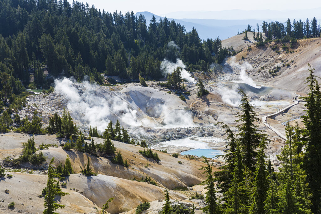
After exploring the town’s rich lumber history, head east to the wild and scenic McCloud River, where you’ll pass three breathtaking waterfalls. Back on the main byway, take in panoramic views of volcano-carved mountains as you pass picturesque rivers, lakes, and streams. Visit McArthur-Burney Falls Memorial State Park for a view of 129-foot Burney Falls (check for temporary trail closures before visiting).
Ascending into Lassen Volcanic National Park, there will be plenty of opportunities to stretch your legs as you explore hydrothermal features and scenic overlooks with Lassen Peak towering over the landscape. Highlights include the colorful steaming vents at Sulphur Works and the bubbling pools at Bumpass Hell. (Check the park’s website for updates on their spring snow-clearing operations, which can run through June.)
Continue to Highlands Ranch Resort, where you’ll stay in one of seven luxurious meadow-side cottages and enjoy views of mountains, meadows, and lush forest. Just east of the resort, you’ll pass Lake Almanor, one of the largest lakes in Northern California and famous for its water sports. You’ll pass several other lakes, including 564-acre Poison Lake, before repeating the route back to McCloud or traveling further west for a drive north along one of the most scenic stretches of I-5.
Directions
Take CA-89 east from McCloud. Turn right on CA-44, then left on CA-89. Keep left to CA-36, then turn left on CA-44. Turn right on CA-89 to retrace your steps back to McCloud, or continue on CA-44 to I-5 North.
Google Maps Link
Ocean, Mountains, and Desert Along Southern California’s Back Roads
Start/End: San Diego
Total Distance: 744 miles
Recommended time: Four to eight days
On this customizable journey around the southernmost part of the state, you’ll pass through three wildly different ecosystems, experiencing the ocean, an alpine village, a desert oasis, and rolling hills of vineyards on the same trip. If you’ve flown in from out of town, start off with a stay at Cormorant Boutique Hotel, where balconies feature views of the Pacific Ocean and the chic village of La Jolla.
After brunch, drive up to Julian, a mountain gold rush town whose architecture and natural environment look much the same as they did over a century ago. Continue through sweeping vistas of chaparral, sprawling horse ranches, and towering metal sculptures before ascending a winding road up into the San Jacinto Mountains.
In the forested alpine village of Idyllwild, stay at the Strawberry Creek Inn, spending a day or two exploring the village’s art museums and hiking trails. (If doing a shortened version of this road trip, you could also drive down the mountain during your stay to explore attractions you might otherwise miss.)
From Idyllwild, drive south along the eastern shore of the Salton Sea, passing through the Salton Sea State Recreation Area and Bombay Beach. Then head west near the Mexico border before driving north through the Anza-Borrego State Wilderness, while taking in views of sweeping desert landscapes, seasonal wildflowers, palm groves, and cacti. Stop in the village of Borrego Springs to grab an ice cream cone, explore the work of local artists, and pick up a map of the Ricardo Breceda sculptures you’ll pass as you make your way through the park.
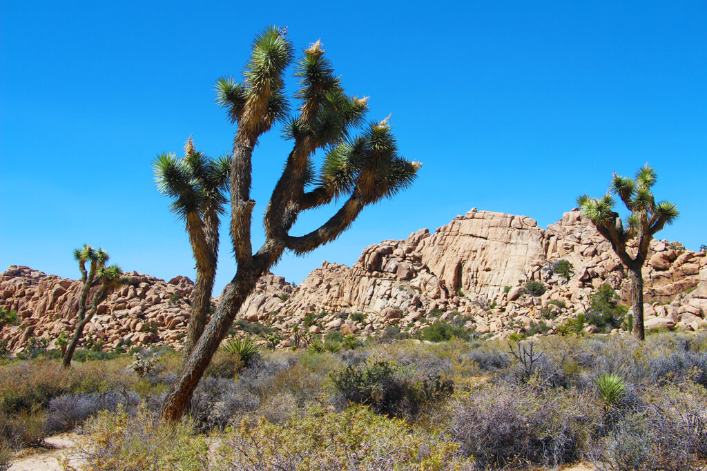
Keep north past the Salton Sea’s western shore and through the Coachella Valley for a stay at the historic Los Arboles Hotel, a short walk to Palm Springs’ famous dining, shopping, and mid-century architecture. From Palm Springs, take a drive through Joshua Tree National Park to experience its scenic valleys, rock formations, and groves of other-worldly Joshua Trees. On the way back to the coast, drive through Temecula Wine Country and stop for a stroll along Temecula’s Old Town Front Street.
Then make your way to Encinitas, a delightful beach town an hour north of San Diego. Stay at the Inn at Moonlight Beach for one last dip in the ocean before driving along the coast back to San Diego.
Directions
San Diego to Julian: Take CA-94 East to I-8 East. Exit to CA-79 North to Julian.
Julian to Idyllwild: Continue on CA-79 and make a right on CA-371 (Cahuilla Road). Turn left onto CA-74 West (Palms-to-Pines Highway). Bear right onto CA-243 to Idyllwild.
Idyllwild to the Salton Sea: Head south on CA-243, then bear left on CA-74. Turn right on CA-111 to the Salton Sea.
Salton Sea to Anza-Borrego State Park: Take CA-111 south to CA-86 south, then take I-8 to Highway S2 through Anza-Borrego State Park.
Anza-Borrego to Palm Springs: Continue north on Highway S2, then turn right on CA-78. Turn right on Highway S22, then left on CA-86 North. Continue to CA-111 toward Palm Springs.
Palm Springs to Joshua Tree: Take I-10 to CA-62 (Twentynine Palms Highway), then turn right on Park Boulevard into Joshua Tree National Park.
Joshua Tree to Temecula: Take I-10 West to Monroe Street. Make a left on Monroe Street, then a right on Fred Waring Drive. Turn left on CA-74, then turn left on CA-371. Turn right on CA-79, then take Butterfield Stage Road north to Rancho California Road. Make a left on Rancho California through Temecula Wine Country, then turn left on Old Town Front Street.
Temecula to Encinitas: Take I-15 South to CA-76 West, to I-5 South to Encinitas.
Encinitas to San Diego: Take South Coast Highway 101 south along the coast to I-5 South to San Diego.
Google Maps Link
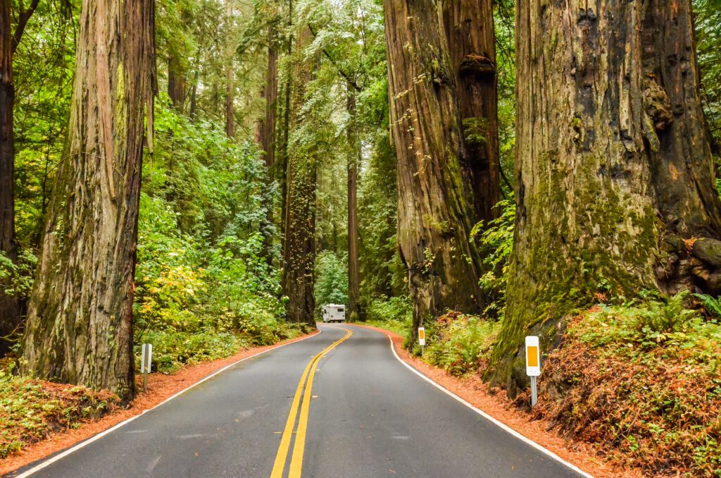
Towering Redwoods Along the Avenue of the Giants and US-101
Start: Garberville
End: Ferndale
Total Distance: 223 miles
Recommended time: Three to eight days
One of the most enchanting road trips in the state winds through the towering forests of California’s redwood coast. The drive takes you through thick stands of old-growth redwood forest, giving you an up-close experience with some of the oldest and largest species on Earth. For those opting to turn a short scenic drive into a weekend getaway, Benbow Historic Inn is an elegant, Tudor-style hotel on the banks of the Eel River, a stone’s throw from where the road trip begins.
Heading north from the inn, a panoramic view opens up to reveal rolling hills of forest and grassland. As the trees start to get denser and taller, you’ll follow the Eel River before entering Humboldt Redwoods State Park, home to the largest contiguous old-growth redwood forest in the world. In the gold rush town of Myers Flat, you can drive your car through a giant redwood to appreciate the scale of these majestic trees. Stop for a half-mile hike to Founder’s Grove, where a fallen redwood known as the Dyerville Giant once stood over 360 feet and lived for 2,000 years. Further north near the coast, Humboldt Bay National Wildlife Refuge features flat trails that wind through Humboldt Bay’s wetland habitat and wildlife.
In the Victorian seaport of Eureka, a stay at Carter House Inns will place you within an easy stroll of Eureka’s old town district. After admiring the area’s well-preserved Victorian architecture, explore the six-mile Eureka Waterfront Trail along the shores of Humboldt Bay.
North of town, the Redwood National and State Parks protect nearly half the world’s old-growth redwoods. A stay at the Historic Requa Inn places you at the north end of the park, right on the Klamath River. From there you’ll have easy access to hikes along fern-draped canyon walls on the Fern Canyon Trail (free parking permit required) or an easy stroll through the towering redwoods at Lady Bird Johnson Grove.
For the return trip, explore the picture-postcard Victorian village of Ferndale while staying at the historic Victorian Inn or Gingerbread Mansion Inn.
Directions
Take Highway 101 north from Garberville, then exit north to Avenue of the Giants (CA-254). Turn right on Highway 101 when CA-254 ends past Pepperwood. Follow Highway 101 to Eureka and Redwood National and State Parks.
Google Maps Link
California’s Gold Rush History Along the Golden Chain Highway
Start: Nevada City
End: Oakhurst
Total Distance: 226 miles
Recommended time: Two to four days
Travel back in time to California’s Gold Rush with a scenic trip along Highway 49. The highway stretches just over 200 miles from Nevada City to Oakhurst along the Sierra Nevada foothills, connecting a series of mining towns steeped in history and charm. Along the way, the winding route passes bucolic ranches and vineyards and rolling straw-colored hills dotted with oaks.
At the northern terminus of Highway 49, Nevada City is a picture postcard introduction to California’s gold rush history (the entire downtown district is a national historic landmark). Five miles away in Grass Valley, the Empire Mine State Historic Park is the site of one of the oldest-running gold mines in California.
An hour south, at the Marshall Gold Discovery State Historic Park in Coloma, you can visit a replica of the original sawmill where James Marshall first discovered flecks of gold in 1848, sparking a mass migration that changed the course of California’s history. Nearby, the Gold Rush town of Placerville is a charming stop for dinner at an outdoor café and to peruse antique shops and galleries. Rest a night or two at the 10-acre Eden Vale Inn, which began its life in 1919 as a hay barn built by pioneering settlers.
Driving south into Amador County’s Shenandoah Valley, you’ll spot more signs for wineries and tasting rooms, evidence of a new type of gold rush in the region. The small town of Plymouth, founded during the Gold Rush and set amid graceful rolling hills, is a great base for exploring the region, its wines, and a growing number of upscale eateries. The Tuscan-inspired Grand Reserve Inn places you right among the vineyards. Or you might opt for a stay at Hotel Sutter in Sutter Creek, which celebrates Gold Country with the authentic romance of the Old West.
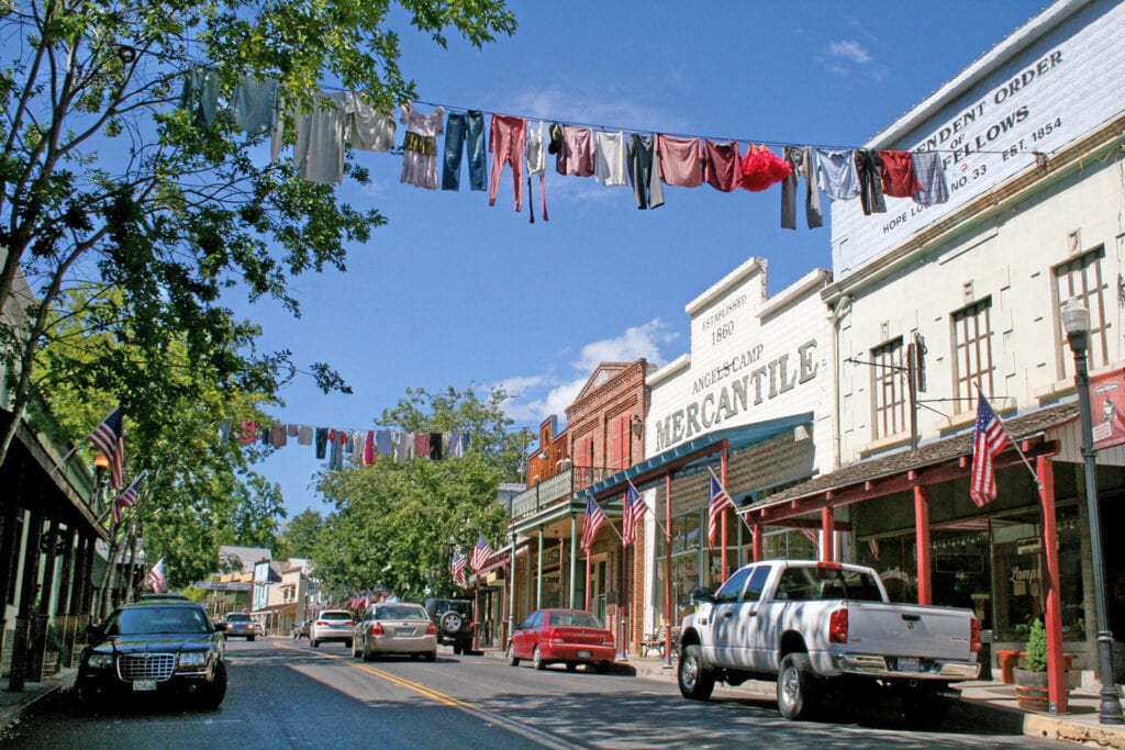
A bit further down the highway in the town of Jackson, the Kennedy Gold Mine offers in-depth tours of the mine’s historic structures. 30 miles away, Angel’s Camp is home to the Calaveras Jumping Frog Jubilee made famous by Mark Twain, along with a museum dedicated to Gold Rush history. Columbia State Historic Park is the best preserved of the California Gold Rush towns, allowing visitors to catch a ride in an authentic stagecoach, order cold sarsaparilla in an Old West saloon, or feel the heat of working in a blacksmith’s shop.
In nearby Jamestown, visitors can sign up for a gold panning lesson with Gold Prospecting Adventures, which operates a historic mining camp on one of the richest creeks in the Mother Lode. Following Highway 49 further south takes visitors past several highway turn-offs leading east to Yosemite National Park. Along the last stretch of Highway 49 in Mariposa, the California Mining and Mineral Museum is an impressive jewel. One of the featured attractions is the 13.8-pound Fricot “Nugget,” a rare specimen of crystallized gold discovered in the American River in 1864.
Directions:
From Nevada City, follow CA-49 south until it ends in Oakhurst.
Google Maps Link
Beach Towns, Spanish Architecture, and Wine Country on the Central Coast
Start/End: Santa Barbara
Total Distance: 305 miles
Recommended time: Three to six days
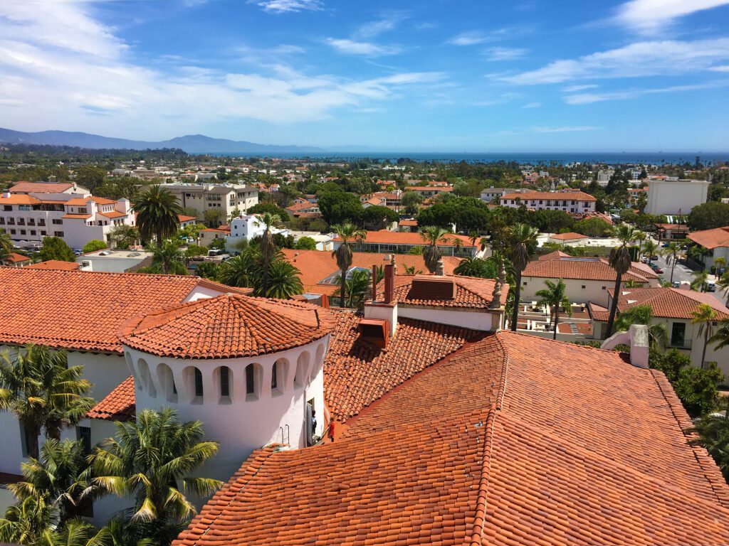
An eclectic mix of sleepy beach towns, rolling vineyards, iconic architecture, and high culture, this trip traverses along some of the most beautiful coastlines in the US. The drive starts in the “American Riviera,” where a stay at Mason Beach Inn immerses you in Spanish architecture and places you just steps away from Santa Barbara’s famous waterfront.
From Santa Barbara, you’ll drive the San Marcos Pass over the Santa Ynez Mountains, through parts of the Los Padres National Forest, and past shimmering Lake Cachuma. Along the way, you’ll get a scenic view of the ranches, vineyards, orchards, and historic valley towns of Santa Barbara Wine Country.
From there head northwest to the coast, passing through Grover Beach, Pismo Beach, and Shell Beach before turning north toward the historic college town of San Luis Obispo (SLO). To fully soak in the history, architecture, and culture of San Luis Obispo, stay a night or two at the newly revamped San Luis Creek Lodge, which blends sophisticated farmhouse design with a surf-inspired vibe, or Hotel San Luis Obispo which is a sleek, modern urban retreat with two delicious restaurants, a pool, and a rooftop bar.
Continue north to Paso Robles Wine Country, where you’ll pass family-owned tasting rooms tucked away among vineyards, farmland, and cattle ranches. Then, head west to the seaside village of Cambria, where a stay at Oceanpoint Ranch gives you access to nine seaside acres, a “ranch-chic” ambiance, and a private path to Moonstone Beach.
Driving south from Cambria along the ocean, you’ll pass through the tiny, quaint town of Harmony and slightly larger Cayucos. Further south, you’ll take a scenic tour of Morro Bay, a great stop to admire gigantic Morro Rock just off the shore, or a quick hike in Montana de Oro State Park. End the trip with one more chance to see Santa Barbara Wine Country and an optional stop in the Danish village of Solvang as you make your way back to Santa Barbara.
Directions
Santa Barbara to San Luis Obispo: Take Highway 101 north out of Santa Barbara, then exit to CA-154. Take CA-154 until it re-joins Highway 101 past Olivos. Take Highway 101 to San Luis Obispo.
San Luis Obispo to Paso Robles Wine Country Tour: Continue north on Highway 101 to Paso Robles, then exit west (left) to CA-46 (Green Valley Road). Turn right on Vineyard Drive, then turn right on Adelaida Road.
Paso Robles to Cambria: From Adelaida Road, turn right on Nacimiento Lake Drive, then take 101 south to CA-46 West. Turn right onto Cabrillo Highway (CA-1) to Cambria.
Cambria to Morro Bay Scenic Tour (visit Google Maps link for tour route): Go back south on CA-1 to Morro Bay. Turn right on Beach Street to begin the scenic tour.
Morro Bay to Santa Barbara: Take Los Osos Valley Road to US 101, then reverse the route from the first leg of the trip.
Google Maps Link
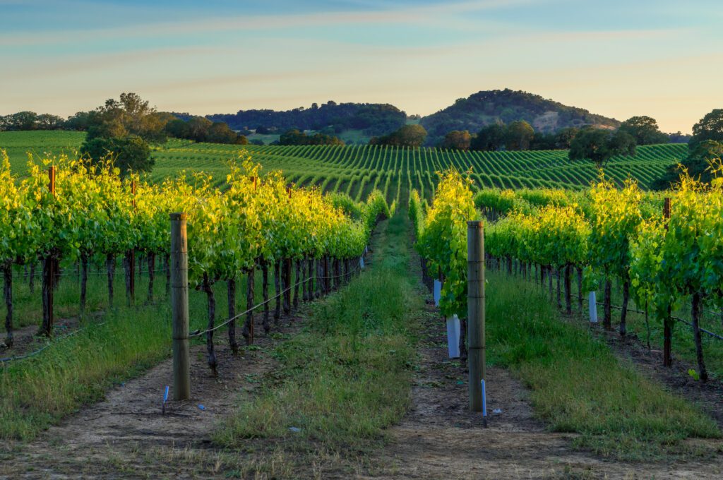
Vineyards, Fine Dining, and Dramatic Landscapes in Wine Country
Start: Napa
End: Mendocino
Total Distance: 140 miles
Recommended time: Three to six days
This trip follows scenic Highway 128 from the open chaparral of northern Napa County to the wild coast of Mendocino. Traversing parts of Napa, Sonoma, and Mendocino counties, the route passes engaging wine country towns, world-class wineries, and nearly a dozen Michelin-starred restaurants (check out Visit 128 for a complete list of wineries and restaurants). The route also reveals an ever-changing landscape of lakes and rivers, mountains and valleys, oak savannahs and redwood forests.
The trip begins with a visit to Napa, arguably the capital of California Wine Country. A great choice for a pre-road trip stay is Milliken Creek Inn, which sits on three acres overlooking the Napa River but is just a stone’s throw from all the action. While in Napa, be sure to visit with local and artisanal food vendors at Oxbow Public Market. You might also opt for a ride on the Napa Valley Wine Train for a leisurely vineyard tour or wine pairing excursion.
As you head north out of Napa, visit the 73-acre Napa River Ecological Reserve for a chance to experience the area’s native flora and fauna, including over 150 bird species. Stop in luxe St. Helena for a hypnotizing stroll down Main Street, a visit to pioneering local wineries, or a tour of the Culinary Institute of America at Greystone. The next stop is Calistoga—known for its mineral-rich waters and natural geothermal pools—for a soak, a mud bath, or a visit to the ever-punctual Old Faithful Geyser.
As you enter Sonoma County, open hillsides become greener and denser, eventually giving way to an ancient redwood forest. Take some time to enjoy Healdsburg, with its vibrant central plaza and undying commitment to the farm-to-table movement. The River Belle Inn sits on a hill overlooking the Russian River, a short walk to Healdsburg Plaza.
As you head into Mendocino County take time to explore the Anderson Valley which is celebrated for its pinot noir and sparkling wines. It offers a wine-tasting experience that is reminiscent of what Napa and Sonoma were like decades ago. While in the Anderson Valley, stay at the Mediterranean-inspired compound, The Madrones, or its sister property tucked in the redwoods, The Brambles.
The last leg of the trip travels north along the Mendocino Coast, passing through the coastal towns of Albion and Little River (home of Van Damme State Park). The trip ends in Mendocino, with a visit to Mendocino Headlands State Park and a stay at the Inn at Schoolhouse Creek. Built in 1862 and opened as the first inn on the Mendocino Coast in 1933, the property features rooms built specifically for traveling motorists.
Directions
From Napa, take CA-29 until it becomes CA-128. Follow CA-128 to Alexander Valley Road. Turn left and follow the signs to Highway 101 South (to Healdsburg). From Healdsburg, head north on Highway 101, then exit back onto CA-128 past Cloverdale. Follow CA-128 to the coast and turn right on CA-1 to Mendocino.
Google Maps Link
Gold Rush Towns and Forested Mountains on the Yuba Donner Scenic Byway
Start/End: Nevada City
Total Distance: 160 miles
Recommended time: Two to three days
Northwest of Lake Tahoe, the Yuba Donner Scenic Byway is a spectacular 160-mile loop that starts in the Sierra Foothills, passes through historic Gold-Rush towns, and runs alongside rushing rivers, dense forests, and rugged mountain landscapes straddling the Sierra Crest.
This curving, mostly two-lane loop through the Tahoe National Forest follows portions of State Highways 20, 49, and 89 with a short segment on Interstate 80. Start the loop in the historic gold-rush town of Nevada City. The charming downtown district is a national historic landmark with one-of-a-kind shops and cafes.
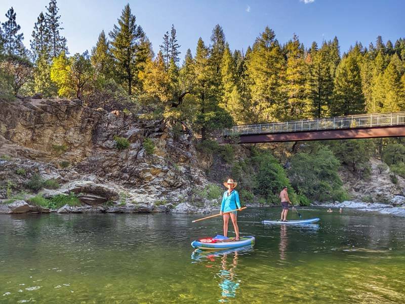
From Nevada City, Highway 49 climbs through the rolling foothills into the forests where pines tower above the road and trails lead deep into the forest. Craggy cliffs can be seen along the way and scenic overlooks provide places to stop and admire the views. A portion of the route follows the North Yuba River, which is a popular destination for anglers and white-water rafting. Stay overnight on the banks of the river at Downieville River Inn in Downieville or Sierra Pines Resort in Sierra City. Then spend a day casting for trout in the river’s emerald waters or zipping through the forested trails.
In Sierraville, turn south to follow Highway 89 to Truckee. Steeped in Old West charm, this outdoorsy mountain town is a captivating hub for world-class skiing, riding, hiking, biking, climbing, and watersports. The Truckee River, Donner Memorial State Park, Donner Lake, and Tahoe National Forest all lie at the town’s doorstep. Consider an overnight stay at the cozy Donner Lake Inn, which is nestled in the forest across from the lake.
From Donner Pass, it’s a quick trip along Interstate 80 to the exit for Highway 20 at Yuba Pass. The highway offers several scenic overlooks before returning to Nevada City.
Directions
From Nevada, follow CA-49 north to Sierraville. In Sierraville, turn south onto Highway 89 toward Truckee. In Truckee, get onto I-80 West and then exit onto CA-20 West to return to Nevada City.
Google Map Link